HydrographyLINZUniversity of OtagoSurveyHydrographicHydrographic surveyScholarshipBanks PeninsulaEducationAHSCPCertificationHydrographic surveyorMount maunganui collegeScienceStudySurvey schoolAustralasian Hydrographic Surveyors CertificationBluffCPHS1DoCECANGisborne District CouncilIHOJimmy van der pauwNautical chartPortsSafetySeaworksStaffStewart IslandStudentSurveyingTaranakiTrainingTRANQUIL IMAGEWestern Work BoatsWomen in Hydrography#aucklandharbourbridge#bathymetric surveys in remote locations#bestcareerever#declanstubbing#HIPP#hydroscheme#Industryandgovermentworkingtogether#mapping the seabed#mappingthegaps#mobilelaserscanningfromavessel#peoplematter#promotion#publicprivatepartnership#surveynews#talentedpeople#transtasmanpartners#worldhydrographyday2023 Mount Everest ChallengeA career in HydrographyAustralasian Hydrographic Society New Zealand RegiAustraliaAwardBack scatterBen hubbardBill dayBruce WallenCAT ACharityCoastalCoastal engineeringCollaborationCommunityComplianceCongratulationsRyanCPHS Level 1 or 2CPHS2CPHSL2CycloneDeclan stubbingDeerDevelopment in the Bay of PlentyDMLDMLScholarshipDolphinsEmergencyFederated States of MicronesiaFeesFieldworkFire fightingFSMFutureLeadersGabrielleGeospatialGeospatial CouncilGISGisborneGraduatesGreg coxHSEHydrographic Survey in SamoaHydrographic surveying on a jet skiHydrographic surveyorsHYPLANJasmin McVeighKate downesKevin smithLand Information New ZealandLaser scanning super structuresLife jacketsLive for MoreMan over boardMarineMauaoMount MaunganuiMulitbeamMultibeamNapierNautical chartingNew PlymouhtNew ZealandNew Zealand Certificate in Hydrographic SurveyingNorthportOIOpen DayPacificPlay hardPohnpeiPohnpei surf and Dive ClubRelaxationRemote vessel survey New ZealandRescureRetirementRiver surveysRNZNSafety of navigationSally coxSand wavesScholarshipAwardSchoolsSea SurveyorSinglebeamSpatial Hydrography Award 2022StudentsSurvey and spatialSurvey requestSurveying a shallow pondSurveying sediment pondSurveyorSurvivalTatai Aho Rau LEARNZTeachersTeamTonkin & TaylorVirtual Field TripWater columnWet drillsWhite pointer sharkWomenWork hardYouthYouthInScience
TAGS

Banks Peninsula Survey - Fieldwork Complete

The fieldwork for Land Information New Zealand’s (LINZ, https://www.linz.govt.nz/sea  ) HS70 Banks Peninsula Hydrographic Survey (HS70) is now complete. The offshore LINZ scope of works focussed on safety of navigation in water depths greater than 10m between Awaroa /Godley Head and Birdlings Flat. The nearshore coastal margin (0m to 10m) along the south coast of Banks Peninsula was also mapped using DML’s inshore survey vessel TUPAIA.  

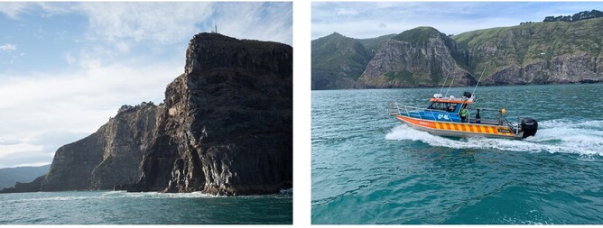
This coastal work was undertaken for Environment Canterbury (ECAN, https://www.ecan.govt.nz/) and the Department of Conservation (DoC, https://www.doc.govt.nz/) in partnership with LINZ. The south coast of Banks Peninsula provided a dramatic backdrop to the nearshore survey operations where towering cliffs, in excess of 200m are not uncommon.  While working in this area, the DML team had regular encounters with local wildlife which they recorded and sent to DoC, using a custom app. 

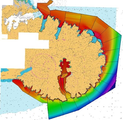
The task of processing and reporting on the 45Tb of Multibeam Echosounder (MBES), mobile Laserscanner (MLS) and Side Scan Sonar (SSS) data captured in the field is now underway at DML’s offices in Mount Maunganui. The final deliverables for the project will be supplied to LINZ, ECAN and DoC in June 2022.