LINZHydrographySurveyHydrographicBanks PeninsulaEducationHydrographic surveyAHSCPCertificationHydrographic surveyorScholarshipScienceStudyUniversity of OtagoAustralasian Hydrographic Surveyors CertificationBluffCPHS1DoCECANGisborne District CouncilIHOJimmy van der pauwMount maunganui collegeNautical chartPortsSafetySeaworksStaffStewart IslandStudentSurvey schoolTaranakiTrainingTRANQUIL IMAGEWestern Work Boats#aucklandharbourbridge#bathymetric surveys in remote locations#bestcareerever#declanstubbing#HIPP#hydroscheme#Industryandgovermentworkingtogether#mapping the seabed#mappingthegaps#mobilelaserscanningfromavessel#peoplematter#promotion#publicprivatepartnership#surveynews#talentedpeople#transtasmanpartners#worldhydrographyday2023 Mount Everest ChallengeA career in HydrographyAustraliaAwardBack scatterBen hubbardBill dayBruce WallenCAT ACharityCoastalCoastal engineeringCollaborationCommunityComplianceCongratulationsRyanCPHS Level 1 or 2CPHS2CPHSL2CycloneDeclan stubbingDeerDevelopment in the Bay of PlentyDMLDMLScholarshipDolphinsEmergencyFederated States of MicronesiaFeesFieldworkFire fightingFSMFutureLeadersGabrielleGeospatialGeospatial CouncilGisborneGreg coxHSEHydrographic Survey in SamoaHydrographic surveying on a jet skiHydrographic surveyorsHYPLANJasmin McVeighKate downesKevin smithLand Information New ZealandLaser scanning super structuresLife jacketsLive for MoreMan over boardMarineMauaoMount MaunganuiMulitbeamMultibeamNapierNautical chartingNew PlymouhtNew ZealandNew Zealand Certificate in Hydrographic SurveyingNorthportOIOpen DayPacificPlay hardPohnpeiPohnpei surf and Dive ClubRelaxationRemote vessel survey New ZealandRescureRetirementRiver surveysRNZNSafety of navigationSally coxSand wavesScholarshipAwardSchoolsSea SurveyorSinglebeamSpatial Hydrography Award 2022StudentsSurvey and spatialSurvey requestSurveyingSurveying a shallow pondSurveying sediment pondSurveyorSurvivalTatai Aho Rau LEARNZTeachersTeamTonkin & TaylorVirtual Field TripWater columnWet drillsWhite pointer sharkWomenWork hardYouthYouthInScience
TAGS

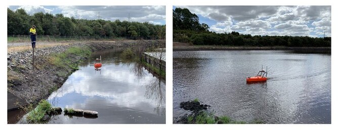
Remotely operated vessel surveys sediment pond

DML recently completed a shallow pond survey using its remotely operated vessel “KOURA”. The small radio controlled vessel undertook a single beam survey of a shallow suspended sediment pond for volume calculations. 

The platform was ideal in this situation due to:
Very shallow nature of the pond
Confined feeder channel
Suspended sediment may have caused issues with a traditional water-cooled outboard engine
Clean up of the vessel and equipment was a lot quicker
Contact with the pond water was kept to a minimum.
If you would like to know more about this capability and whether or not it is suitable for your project, contact info@dmlsurveys.co.nz